


![Hilti PM 20-CG Multi Green Line Laser Level [WORKING] With Batteries 131ft Range](https://i.ebayimg.com/thumbs/images/g/oAcAAOSws7NmTXKk/s-l300.jpg)


![HILTI PRA36 Digital RECEIVER REMOTE Detector for Rotary PRA36 Laser Level [PART]](https://i.ebayimg.com/thumbs/images/g/LoQAAOSwgCxmTVne/s-l300.jpg)


Levels and Surveying Equipment
Land surveyors are responsible for helping construction companies, governmental agencies, and other entities to accurately measure properties and determine boundaries. In order to survey a property, the professional must be equipped with quality surveying tools. The following is an overview of such tools:
When is surveying used?Surveying, also known as land surveying, is a technique that is used to determine land geography, terrain, distances, and angles between specific geographical points. A survey is required when establishing maps and property boundaries. It is also used to identify property locations, including building corners. A survey can also be used as a means of ensuring that government guidelines and laws are being upheld.
What tools do surveyors use?There are a number of important tools land surveyors use to complete their jobs:
- Theodolite: a surveying instrument used to measure angles.
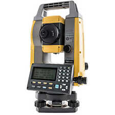
- Total station: an electronic theodolite that is integrated with an EDM (electronic distance measurement). The total station is used to read slope distances from the equipment itself to a designated point. An integrated computer then collects the data and performs the necessary calculations.
- 3D scanners: a piece of equipment that is used to analyze an environment or object by collecting data on its appearance and shape. The data is then used in order to create a 3D shape or model.
- Level: a surveying instrument used to measure the height of points in the distance. The instrument, which consists of a spirit level affixed to a telescope, is typically positioned on top of a tripod.
- Rod: a surveying instrument that is used in determining distance and/or length.
- Measuring tape
- GPS
Available survey levels include the following:
- Dumpy level: the most common type of survey tool used in the field. A telescope is fixed to its support but the leveling head has the ability to be rotated horizontally.
- Y level: as the name suggests, this tool supports a telescope on a y-shaped frame. The telescope is attached via clamps and can be removed when needed.
- Cushing's level: this level has a non-removable telescope that cannot be rotated on its longitudinal axis.
- Tilting level: this instrument has a telescope that can be rotated horizontally and can also be tilted approximately four degrees.
- Cooke's reversible level: a combination of the Y and the dumpy level, this instrument has a telescope that can be reversed on a swivel without the need for moving the entire instrument.
- Automatic level: in this level, a compensator is attached to the telescope to provide more accuracy.